Routes 2017
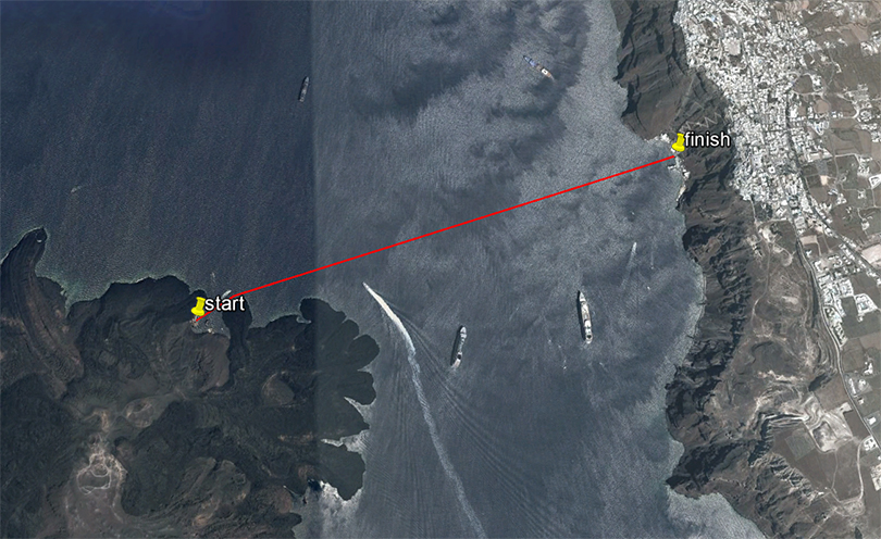
Santorini Experience Open Water Swimming
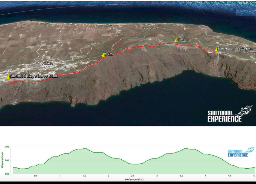
The route of 5 km. starts slightly downhill for about 250 meters to a wide dirt road and then follows a strongly uphill path 1,250 m long, with an average gradient of 12%. Then the dirt road path narrows and the form of the ground changes with several stones which need increased attention. The slope is downhill until the reversal point located midway (2.5 km.) where there will be a power station.
On returning we meet the maximum slope just before the 3.5 km., which is close to 40% (!) for about 100km. The last 1.5 km. of the route is downhill.
Technical characteristics of the route:
Start – stop Elevation: 146 m.
Reversal point Elevation: 173 m.
Maximum altitude: 293 m.
Minimum altitude: 135 m.
Total positive elevation: 313 m.
Maximum slope: 37.6 %
Route Ground: soil path with recessed stones in some places.
5 km. Route
The route of 5 km. starts slightly downhill for about 250 meters to a wide dirt road and then follows a strongly uphill path 1,250 m long, with an average gradient of 12%. Then the dirt road path narrows and the form of the ground changes with several stones which need increased attention. The slope is downhill until the reversal point located midway (2.5 km.) where there will be a power station.
On returning we meet the maximum slope just before the 3.5 km., which is close to 40% (!) for about 100km. The last 1.5 km. of the route is downhill.
Technical characteristics of the route:
Start – stop Elevation: 146 m.
Reversal point Elevation: 173 m.
Maximum altitude: 293 m.
Minimum altitude: 135 m.
Total positive elevation: 313 m.
Maximum slope: 37.6 %
Route Ground: soil path with recessed stones in some places.
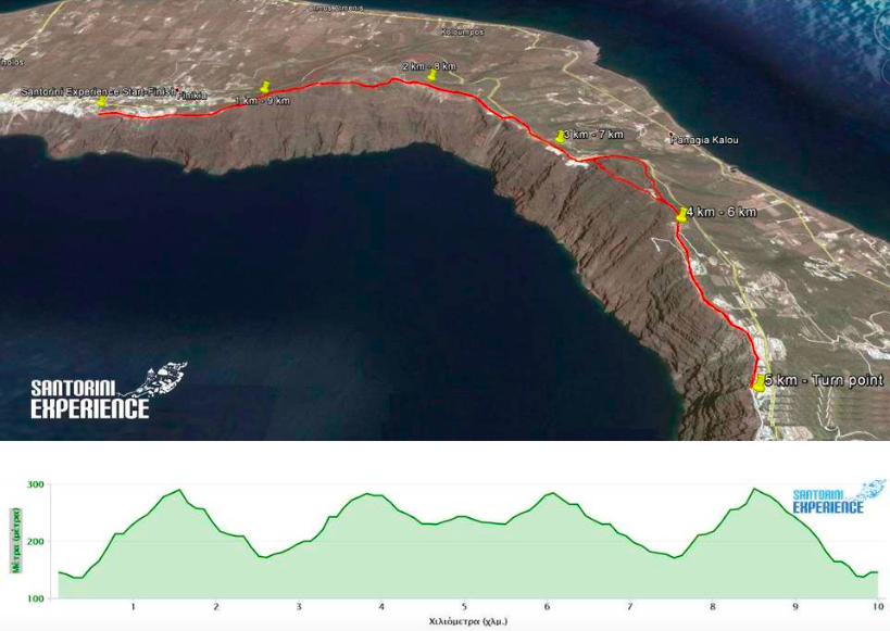
10km. Route
The route of 10 km. starts slightly downhill for about 250 meters to a wide dirt road and then follows a strongly uphill path 1,250 m long, with an average gradient of 12%. Then the dirt road path narrows and the form of the ground changes with several stones which need increased attention. The slope is downhill until the point located at 2.5 km. where there will be the first power station. Then the route continues on asphalt road for about 660 meters with moderate uphill slope, to get back on a path where the ground is soft and somewhat loose soil so you need a little attention as it is relatively slippery, with very steep slope for about 700 meters with breathtaking view. Attention at this point, you must move as far on the left side of the trail as possible.
The intense uphill ends at 3.8 km. at the chapel of Prophet Elias, where a concrete steep alley follows up to 4.5 km. which is 500 meters before the reversing point and the second power station. The way back is the same except for the point after the 6th km. where before you reach the chapel of Prophet Elias, you take the paved path (also needs enough attention) on the right side until you get back on the asphalt road at the 7th km. and in about 600 meters you get back on the path for the return where we meet the maximum slope just before 8.5 km., which is close to 40% (!) for 100 m. The last 1.5 km. of the route is downhill.
Technical characteristics of the route:
Start – stop Elevation: 146 m.
Reversal point Elevation: 245 m.
Maximum altitude: 293 m.
Minimum altitude: 135 m.
Total positive elevation: 570 m.
Maximum slope: 37.6 %
Route Ground: soil path with recessed stones in some places, asphalt road, paved path.
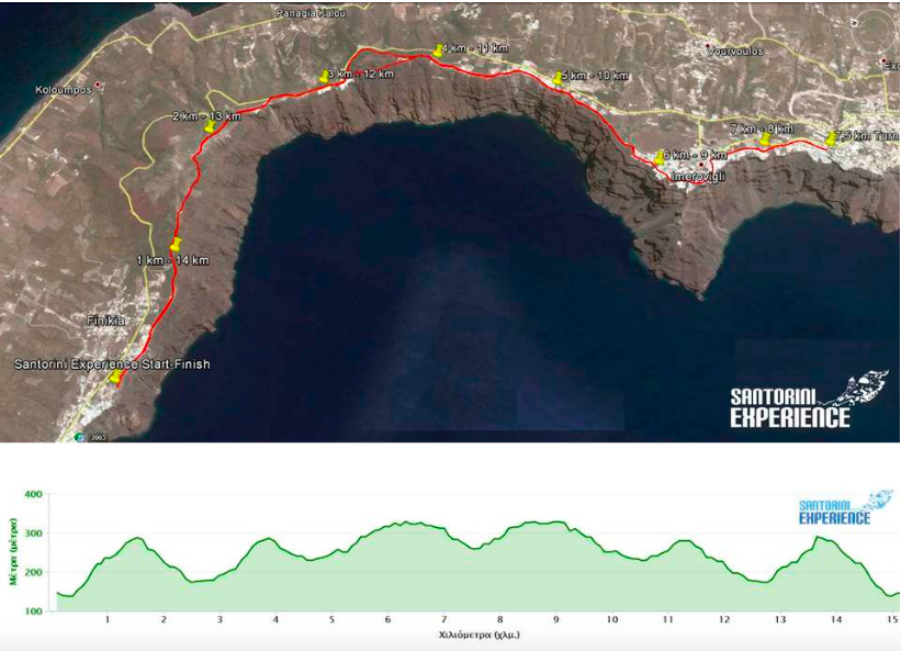
15km Route
The route of 15 km. starts slightly downhill for about 250 meters to a wide dirt road and then follows a strongly uphill path 1,250 m long, with an average gradient of 12%. Then the dirt road path narrows and the form of the ground changes with several stones which need increased attention. The slope is downhill until the point located at 2.5 km. where there will be the first power station. Then the route continues on asphalt road for about 660 meters with moderate uphill slope, to get back on a path where the ground is soft and somewhat loose soil so you need a little attention as it is relatively slippery, with very steep slope for about 700 meters with breathtaking view. Attention at this point, you must move as far on the left side of the trail as possible.
The intense uphill ends at 3.8 km. at the chapel of Prophet Elias, where a concrete steep alley follows up to 4.5 km. which is 500 meters before the reversing point and the second power station. The way back is the same except for the point after the 6th km. where before you reach the chapel of Prophet Elias, you take the paved path (also needs enough attention) on the right side until you get back on the asphalt road at the 7th km. and in about 600 meters you get back on the path for the return where we meet the maximum slope just before 8.5 km., which is close to 40% (!) for 100 m. The last 1.5 km. of the route is downhill.
Technical characteristics of the route:
Start – stop Elevation: 146 m.
Reversal point Elevation: 277 m.
Maximum altitude: 334 m.
Minimum altitude: 135 m.
Total positive elevation: 834 m.
Maximum slope: 37.6 %
Route Ground: soil path with recessed stones in some places, asphalt road, paved path.