Routes 2020
Open Water Swimming Route of Santorini Experience
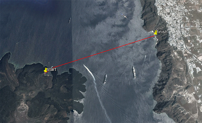
Location: Volcano – Old Port of Fira
The distance of the Santorini Experience open water swimming route is 1.5 miles (2.4 km)
Start/ Finish
The starting line* will be in the water in the harbor of the volcano. The finish line is located at the pier of the old port of Fira in a specially formatted finish arch. In order to exit a pool ladder will be available.
Along the way there will be many experienced lifeguards and watercrafts for the safety and protection of swimmers. If you don’t feel well and you are not able to continue, you may move your hands up and down or move to the nearest watercraft.
* Swimmers will be transferred by boat to the starting area.
Regulations
Participants can compete with goggles or swimming mask and swimsuit or wetsuit. For those who wish to simply swim the course, the use of snorkel masks and fins will be permitted. However these participants will not be timed.
Other Information
In Santorini Experience there is timing. Distinguished categories will be formed depending on the final participation entries, while an extra classification for those wearing wetsuits will be added.
Swimmers should be at the old port at least 1 hour before the scheduled starting time.
The contestants can use the cable car connecting Fira to the old port.
Spectators could visit the port by the stairs or by the cable car. They can enjoy and share this unique experience from any point of Fira or Santorini with a view to Caldera.
10km. Trail Running Route of Santorini Experience
Location: Oia – Desalination Plant
The10 km trail running route starts slightly downhill for about 250 m on a wide dirt road and then follows a steeply uphill path of 1,250 m. with an average gradient of 12%. The trail then narrows and the terrain changes shape with several rocks which requires increased caution. The slope is downhill up to the 2.5 km point. where there will be the 1st feeding station. The route then exits onto tarmac for about 660 metres with a moderate uphill gradient, to re-enter a path whose terrain is soft and somewhat loose soil so some care is needed as it is relatively slippery, with a very steep gradient for about 700 metres with breathtaking views.
The intense uphill ends at 3,8 km. at the chapel of Prof. Ilias church where a concrete downhill path follows until 4.5 km. and then about 500 meters remain until the turning point and the 2nd feeding station. The return route is the same except for the point after the 6th km. Where before the chapel of Prof. Elias, we take the paved path (which also needs a lot of attention) on the right until we reach the tarmac again at km 7. and after about 600 meters we rejoin the path on the way back where we meet the maximum gradient just before 8.5 km. which approaches for 100 m. 40% (!). The last 1,5 km. of the route is downhill.
Technical characteristics of the route:
Start – stop Elevation: 146 m.
Reversal point Elevation: 245 m.
Maximum altitude: 293 m.
Minimum altitude: 135 m.
Total positive elevation: 570 m.
Maximum slope: 37.6 %
Route Ground: soil path with recessed stones in some places, asphalt road, paved path.

“Aristides Alafouzos” 15km Trail Running Route of Santorini Experience
Location: Oia – Desalination Plant
The15km trail race starts slightly downhill for about 250m on a wide dirt road and then follows a steeply uphill path of 1,250m with an average gradient of 12%. The trail then narrows and the terrain changes with several rocks so increased caution is required. The slope is downhill up to the 2.5 km point. where there will be the 1st feeding station. The route then exits onto tarmac for about 660 metres with a moderate uphill gradient, to re-enter a path whose terrain is soft and somewhat loose soil so some care is needed as it is relatively slippery, with a very steep gradient for about 700 metres with breathtaking views. Be careful at this point to move as far left as possible on the path.
The intense uphill ends at 3,8 km. at the chapel of Prof. Ilias church where a concrete downhill path follows until 4.5 km. and then there are about 500 meters to the 2nd feeding station located at km 5. The next 2 km or so are also quite uphill on firm but fairly hard terrain passing through Imerovigli with the views continuing to be stunning. We continue to the entrance of Fira to reach the church of Agios Gerasimos where the 3rd feed station and turnaround point is located. The return route is the same except for the point after the 11th km. where before the chapel of Prof. Ilias, we take the paved path (which also needs a lot of attention) on the right until we reach the asphalt again at km 12. and after about 600 meters we rejoin the path for the return where we meet the maximum gradient just before the 13,5 km. which approaches for 100 m. 40% (!). The last 1.5 km. of the route is downhill.
Technical characteristics of the route:
Start – stop Elevation: 146 m.
Reversal point Elevation: 277 m.
Maximum altitude: 334 m.
Minimum altitude: 135 m.
Total positive elevation: 834 m.
Maximum slope: 37.6 %
Route Ground: soil path with recessed stones in some places, asphalt road, paved path.
